Potential of premium GIS data. Why public flood data can be risky business?


Hurricane Milton, Hurricane Helene, Hurricane Debby, historic flooding in New York, Vermont, and Valencia, Spain... The reality is, there’s a new reality when it comes to flood risk. It’s not just that it feels like there are more and more severe flood events each year – there are; flood risk is fundamentally changing before our eyes as climate change creates more severe weather events.
Many renewable energy developers are investing significant time and resources in projects based on FEMA's online public flood data. Despite being a go-to resource, this data might be putting your projects in jeopardy due to significant issues with FEMA’s flood modeling that do not account for climate change or FEMA’s lack of online data. In the rapidly evolving world of solar energy development, accurate and comprehensive data is the cornerstone of risk management and strategic planning.
However, an alarming reality looms over solar developers: the public flood data they often rely on, especially from FEMA, is fraught with critical shortcomings and significantly underestimates flood risk. This leaves developers, owners/operators, and lenders over-exposed to risk, including direct damage/losses during severe events, financial uncertainty with future premiums, and devalued assets as insurers and lenders adjust for the new normal.
Concerningly, FEMA’s modeling focuses on historic flood events to show current flood zones and severely underestimates present-day flood risk based on the effects of climate change. With a mere 40% coverage of the U.S., FEMA's flood data leaves vast regions in the dark, creating blind spots in early-stage risk assessment for solar projects. Even more concerning is that a staggering 72% of FEMA's flood maps are outdated, failing to reflect the dynamic impacts of climate change in recent years and the decades to come. This gap in accurate and up-to-date information not only misguides solar developers but also places their investments and the sustainability of their projects at significant risk.
In this blog post, we delve into the implications of these startling statistics and explore how solar developers can safeguard their projects with more reliable and accurate flood data solutions from day one than those publicly available.
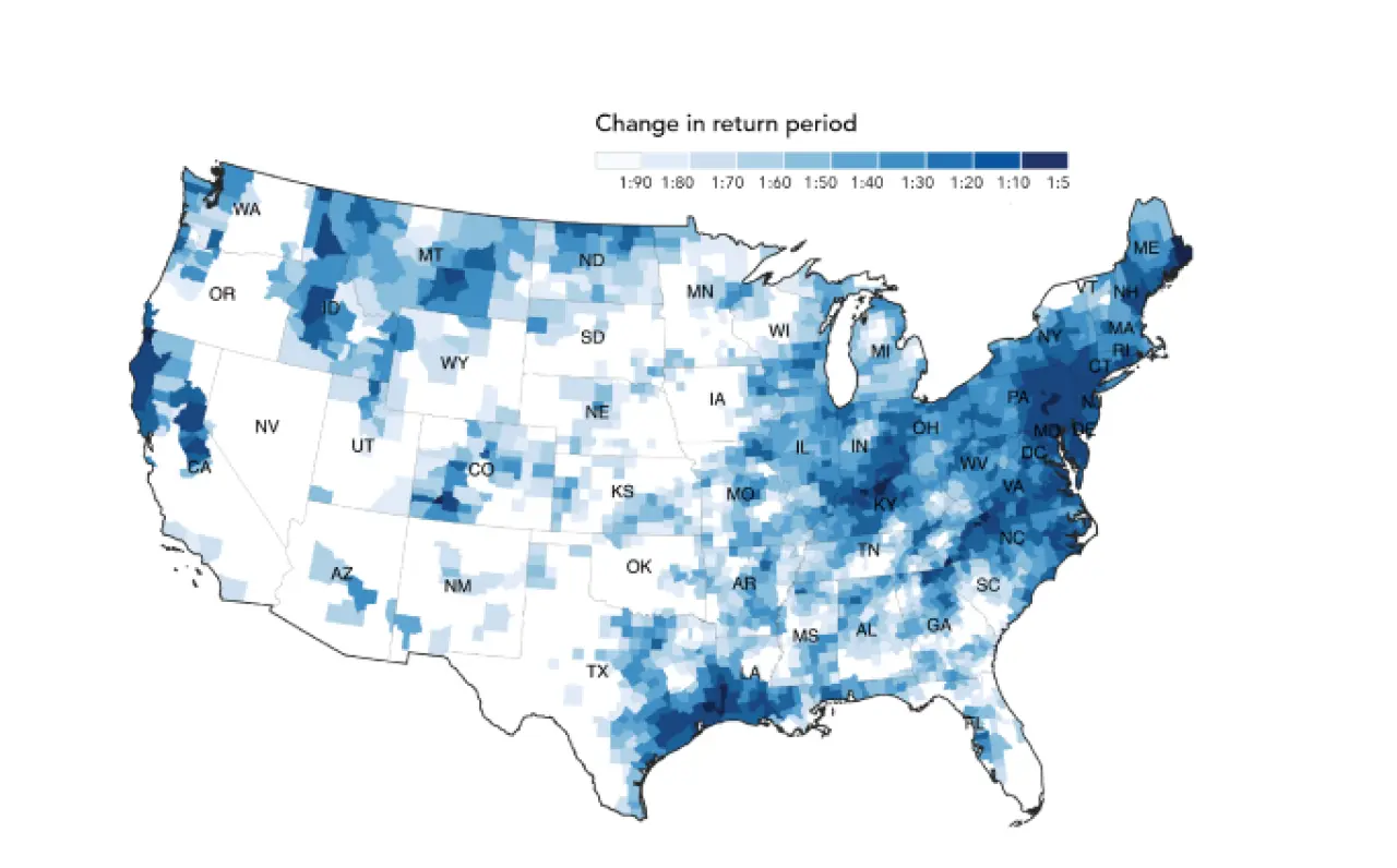
U.S. properties face double the risk of 1-in-100-year floods compared to FEMA zones
In the dynamic landscape of solar development, utilizing public flood data such as FEMA's can be a risky oversight. A critical limitation of this data lies in its backward-looking nature. While historical flood information is valuable, it fails to paint the complete picture needed for thorough risk assessment in today's rapidly changing climate.
1. Historical data isn't enough: FEMA's approach predominantly evaluates past flooding events, offering a retrospective analysis rather than a forward-looking, climate-adjusted one. This historical focus can lead solar developers to miss current flood-prone areas that have emerged or worsened due to climate change. In an era of rapidly evolving climate patterns, historical data alone is no longer sufficient. While FEMA aims to re-review flood maps every 5 years, many maps are outdated by their own standards – some still date back to the 70s and 80s. Regardless, even when the maps are refreshed, the models are still not climate-adjusted and only backwards-looking, omitting major categories of flood risk.
2. Understanding the limitations of FEMA’s flood modeling: a critical aspect often overlooked is that FEMA’s flood modeling omits certain types of flood events. Specifically, it does not account for flood risks arising from heavy rainfall, small river, or tributary channel flooding. These factors are increasingly relevant due to climate change, especially for solar developers sitting projects in flat areas further away from large river channels prone to flooding from such causes.
First Street highlights this concern: “The current flood risk standard in the US, FEMA’s SFHA designation, does not account for precipitation, leaving over half of the country’s risk unaddressed.” This gap in FEMA's analysis underscores the importance of comprehensive flood data that considers all potential flood sources, ensuring solar developers have a complete risk assessment for their project sites.
3. The need for predictive insights: the absence of predictive modeling in FEMA's data is a significant drawback. As solar developers, the inability to foresee how flood risks will shift in the future can lead to strategic missteps. In the face of climate change, flood patterns can alter dramatically, and areas previously deemed safe might become high-risk zones. This evolving risk landscape necessitates a forward-looking approach to flood risk assessment.
Recognizing these limitations is crucial for solar developers who need to make informed decisions about site selection and long-term project viability. The reliance on data that only looks backward is akin to driving while only looking in the rearview mirror – it neglects the road ahead, where the actual risks and opportunities lie.
How can Premium Flood Data protect your developments?
The challenges posed by relying on traditional flood data call for a more robust and future-ready solution. Enter the Premium Flood Data set for PVcase Prospect, a groundbreaking collaboration between Anderson Optimization by PVcase and First Street. Designed to transcend the limitations of conventional flood risk assessments, this state-of-the-art tool is revolutionizing how solar developers approach site planning and risk management.
1. Accurate flood models based on climate change: in a significant leap forward, this tool integrates 30-year predictive insights. This forward-looking feature is crucial for the long-term viability of solar projects, providing developers with a much-needed window into climate-based future flood risks and allowing them to plan with a vision that extends well beyond the present.
2. Comprehensive coverage: unlike FEMA's data, Premium Flood Data offers exhaustive flood risk maps, covering the entirety of the U.S. This comprehensive scope includes detailed assessments for both 100-year and 500-year flood events, ensuring no area is left unexamined.
3. High-resolution data: the precision of Premium Flood Data is unmatched. Offering high-resolution data down to individual properties, it empowers developers with the granularity needed for meticulous and accurate planning. This level of detail is instrumental in making informed decisions about site selection and project development.
4. Automated analysis for efficient decision-making: one of the key benefits of Premium Flood Data is its integration into PVcase Prospect to automate analysis processes. This feature streamlines the assessment of flood risks, significantly reducing the time and resources typically required for manual evaluations. Developers can easily identify potential risk areas and exclude them from their automated buildable area analysis, enabling faster and more efficient decision-making in the early stages of project development.
This innovative solution is not just an upgrade — it represents a paradigm shift in how solar developers approach flood risk exposure and assessment, moving from the reactive status quo to a proactive, data-driven strategy.
Saving you more than time, the right data saves your investments
When considering an upgrade to Premium Flood Data, it's natural to weigh the cost against the benefits. In the solar development industry, where budget allocation and cost-efficiency are key, every investment counts. However, it's vital to consider the broader picture – especially the financial repercussions of inadequate flood risk management.
- The high cost of flood-related losses: in solar project development, the stakes are high. The cost of damage from unforeseen flood events can run into millions of dollars, not to mention the subsequent operational disruptions and reputational damage. In such a scenario, the 'savings' from not upgrading can quickly turn into a costly oversight.
- Investing in security: the initial investment in Premium Flood Data should be viewed not just as a purchase, but as a strategic investment in your project's security and sustainability. By providing detailed, predictive insights, this tool significantly enhances your risk management capabilities, allowing for more informed decision-making and long-term planning.
- A calculated decision: when you consider the potential costs of flood-related project delays, damage to equipment, and loss of operational time, the price of upgrading becomes a small yet crucial part of safeguarding your investment. In essence, the cost of Premium Flood Data is dwarfed by the potential financial and operational risks it helps you avoid.
- Embracing the 'fail fast' methodology: a crucial aspect of effective land siting is the ability to quickly weed out parcels that don't meet your project's needs. By adopting a 'fail fast' mindset, you can save valuable time and resources, focusing your efforts on the most viable and profitable projects with adequate acreage. This approach is central to our Land Siting Guide, designed to help solar developers streamline their process using industry best practices and GIS Automation. By following this method, you ensure that only the best parcels are pursued, greatly enhancing project success rates.
While the upfront cost of upgrading to Premium Flood Data is an important consideration, it's essential to evaluate it in the context of the value and protection it offers. The enhanced risk management and predictive capabilities it provides can not only save costs in the long run but also ensure the resilience and success of your solar projects.
Countering the misconception: why early Flood Data matters even when planning hydrological studies
While it’s true that solar developers don't solely rely on FEMA data to greenlight a project, opting instead for comprehensive hydrological studies, the role of preliminary flood data cannot be understated. Here's why initial flood assessments remain invaluable:
- Early stage insights: hydro studies come into play later in the project lifecycle. In the initial stages, developers need quick, reliable insights to gauge potential risks. Premium Flood Data fills this gap, offering valuable early assessments in areas that might lack FEMA maps altogether.
- Mitigating early development costs: the early phases of project development often involve significant soft and hard costs. Without proper early insight, these investments might be channeled into less viable sites. Premium Flood Data offers a cost-effective way to sift through potential sites, ensuring resources are allocated to the most promising locations.
- Expense of hydro studies: hydrological studies are an expensive affair. By using comprehensive flood data from the outset, developers can better judge which sites are worth this substantial investment.
- Land requirement realities: engaging with landowners for site control is a delicate and time-sensitive process. Discovering too late that additional land is needed can set a project back significantly. Early flood risk assessment helps developers understand land requirements upfront, preventing future complications in land acquisition.
- Advantage for early-stage developers: for developers focusing on early-stage projects, quality due diligence can be a game-changer. Demonstrating thorough initial assessments, like those offered by PVcase Prospexr Premium Flood Data, sets them apart in a competitive market. It not only aids in selling sites but also upholds their reputation by ensuring they don’t overpromise on workable land.
In essence, while detailed hydrological studies are indispensable for final decision-making, the role of preliminary flood risk assessment in shaping the early stages of solar development is equally critical. It's about setting the right foundation, minimizing risks, and optimizing resource allocation from day one.
Final thoughts
By now, it should be evident that Premium Flood Data is more than just an upgrade — it's a crucial tool for today's solar developer. It goes beyond what traditional flood risk assessments offer, bringing detailed, forward-looking, and climate-adapted information. Switching to this advanced data set is a smart decision for any solar project. It not only helps in achieving success in current projects but also prepares them to face future climate-related challenges.

See it for yourself
Schedule a demo today to see how Premium Flood Data can revolutionize your approach to risk assessment and decision-making.