Environmental hazard risk: the latent impact of climate hazards on solar projects


The solar industry has experienced rapid growth for years as it responds to climate change. Yet, as much as it expands, the climate continues to shift inexorably, increasing the impact of environmental hazards.
Floods, wildfires, and extreme winds are becoming more frequent and severe, posing tangible threats to solar infrastructure.
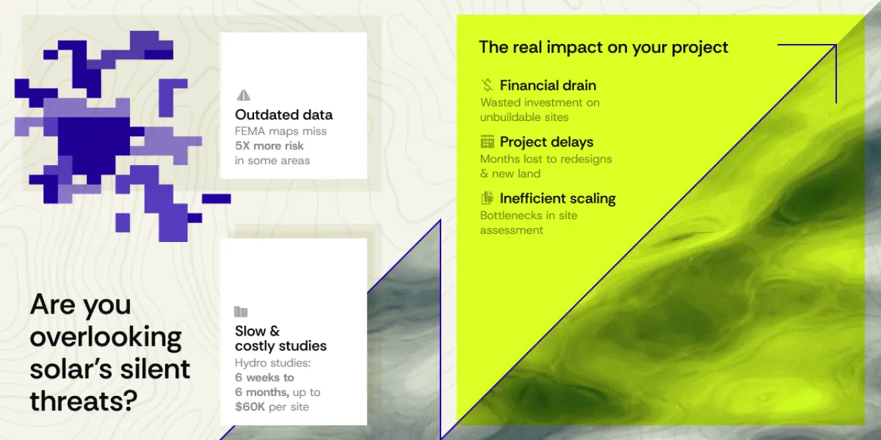
However, many solar developers and key decision-makers are oblivious to these significant, unacknowledged risks, largely due to reliance on outdated, incomplete, or generalized data for solar project hazard analysis. Without accurate information, this "insidious" threat can quietly undermine projects from inception through operation.
The cascading costs of overlooking climate hazards
Ignoring environmental hazards carries a significant cost, impacting initial investments and long-term operations. These burdens quickly add up, posing serious challenges for renewable energy developers.
Financial impact
Without a precise environmental hazard analysis, resources are wasted on unsuitable sites due to high climate risk. This means spending money on detailed studies, like expensive Hydrology and Hydraulics (H&H) assessments, only to discover the site is fundamentally flawed.
Higher costs down the line: This might involve acquiring additional land to move away from hazardous areas or undertaking costly redesigns of the solar farm layout late in the project's life.
"Bad assets" in M&A: During mergers and acquisitions (M&A), projects with unquantified or underestimated environmental risks can become significant liabilities, leading to diminished returns and unexpected problems for the acquiring company.
Increased operational costs & damage: Once a solar farm is built, the occurrence of unmitigated climate hazards can result in substantial repair costs, operational downtime, and long-term inefficiencies. The result is a lower profitability of the asset over its lifespan.
Insurance & viability threats: Underestimated or unaddressed risks can also lead to significantly higher insurance premiums. Furthermore, as financial institutions, investors, and insurers increasingly scrutinize climate-related physical risks, projects in high-risk areas may become uninsurable or directly unviable.
Time impact
Major delays in the project’s development are another direct consequence of unforeseen hazards. The time needed for redesigns, to obtain new permits, and even to acquire additional land, all push back project completion dates. As traditional, site-specific solar site due diligence processes are already slow by nature, these hazards create bottlenecks that hinder the speed at which initial project evaluations can be completed, slowing down the entire development pipeline.
Efficiency and scale impact
The inability to rapidly and accurately evaluate a large number of potential sites for environmental risk limits a developer's reach and speed in the market. When foundational risk data is missing or requires extensive manual processing, it becomes difficult to scale development operations efficiently. Consequently, the company’s ability to grow its portfolio of solar projects is diminished.
Reputational & competitive risks
Neglecting environmental hazards can also inflict significant reputational and competitive risks. Failed solar projects due to unforeseen climate events can damage a developer's standing, while relying on outdated risk assessment methods can cause companies to fall behind competitors leveraging advanced climate intelligence for more resilient sites and reliable projects.
Why current risk assessment methodologies fall short
Relying on traditional methods for hazard assessment can create significant blind spots. These conventional approaches often fail to accurately capture the actual climate risks, leading to underestimated dangers and potentially costly surprises.
The accelerating frequency of climate events
Relying solely on historical climate data is no longer adequate for accurately projecting future risks. Climate patterns change rapidly, meaning past trends alone cannot predict future events.
The United States is experiencing a rise in costly climate events. On average, the U.S. now sees 1.5 billion-dollar precipitation-related flooding events each year, which is a significant increase from the early 1980s. Furthermore, data shows extreme single-day precipitation events have increased substantially since 1980. This trend underscores the need for solar project hazard analysis that looks beyond past averages.
FEMA's critical limitations
The Federal Emergency Management Agency's (FEMA) widely used Special Flood Hazard Area (SFHA) maps are frequently based on historical data, but do not accurately show current or future climate conditions.
A major gap in FEMA's SFHA definitions is that they explicitly do not account for rainfall-driven, or "pluvial," flooding. This type of flooding, caused by intense local rainfall that overwhelms drainage systems, is increasingly common.
FEMA's current methodologies do not include the changing impacts of climate on flood risk over time, either. Thus, projects are left vulnerable to future changes in extreme weather patterns.
A considerable portion of flood loss claims, estimated at 40-60%, occur outside official FEMA SFHA zones. This highlights the substantial gaps in FEMA's current flood risk mapping.
The problem with traditional Hydro studies
Many Hydrology & Hydraulics studies, which are often expensive, still depend on historical precipitation data, such as that from NOAA Atlas 14. But, as with FEMA, the historical focus translates into often underestimating the true impact of current and future climate patterns.
Additionally, these detailed studies are typically costly and take a long time to complete, creating a significant barrier for assessing solar sites in the early stages of development. The results from these traditional studies are usually provided as static PDF documents, which makes them difficult to integrate directly into modern solar site prospecting or solar design platforms, slowing down analysis and planning.

The PVcase Prospect solution
Given the limitations of traditional risk assessments, a new approach is needed to truly understand and manage the environmental risk for solar projects. Unlike other site selection tools, PVcase Prospect integrates crucial climate hazard data directly into your parcel search and analysis, directly addressing these challenges.
Key Differentiators
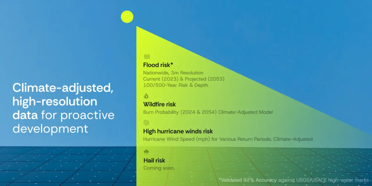
Climate-adjusted & high-resolution data: PVcase Prospect’s data goes beyond simply looking at past averages. Instead, it provides projections that consider a changing climate, delivered with a high level of detail. This advanced data is seamlessly integrated into the buildable area analysis, allowing for easier and faster site selection.
Automated and integrated workflow: Risk analysis is a smooth process within the platform, meaning there is no more manual data handling and faster solar site due diligence.
Powered by validated science: Every hazard layer is built upon and continuously checked by peer-reviewed models and trusted scientific organizations like the First Street Foundation, ensuring the reliability of every assessment.
PVcase Prospect's hazard layers
Using the platform’s comprehensive hazard layers provides users with actionable insights into potential threats, allowing for smarter planning and more resilient solar projects.
Premium Flood Risk Assessment
The Premium Flood Risk Assessment offers nationwide, high-resolution (3-meter) flood depth data. It includes 100-year and 500-year flood zone analysis for both current (2023) and projected (2053) risk, including precise flood depths. Seeing varying flood depths allows for rapid adjustments of layouts, which can optimize the buildable area of a solar site.
With this assessment, developers can quickly identify unviable sites early in the selection process based on flood vulnerability, preventing costly mistakes in land acquisition. Furthermore, by using this data in early stages, they can significantly reduce the immediate need for expensive, time-consuming H&H studies.
Additionally, precise flood depth data allows for an early optimization of crucial design elements like module height, the appropriate foundation types, drainage solutions, and site grading. Thus, it ensures the solar farm is built to withstand predicted flood elements.
The First Street Flood Model
PVcase Prospect’s Premium Flood Risk Assessment is built upon the First Streets Flood Model (FS-FM).
The model’s predictions show a 92% correspondence with over 2,400 High Water Marks (HWMs) from 22 flood events collected by USGS and USACE.
For instance, for Hurricane Helene in September 2024, the FS-FM's 1-in-500-year flood extent predictions showed a 98% correspondence at 3m resolution with USACE HWM observations. This event, considered a 1-in-5,000-year storm by NOAA Atlas 14, was identified as a 1-in-500-year event according to First Street's climate-adjusted Precipitation Model (FS-PM).
The FS-FM uses a physics-based approach to simulate how floods behave. The model accounts for complex local drainage patterns, critical for accurate pluvial flood assessment.
The FS-FM also integrates the FSF-PM, which employs early 21st-century rainfall records and climate adjustments. This helps overcome the limitations of outdated NOAA Atlas 14 data, as the FSF-PM corrects for outdated data, removes extreme event observations, and inconsistent calculation methods found.
Premium Wildfire Risk Assessment
As much as floods, understanding wildfire risk is crucial for solar project development in many regions.
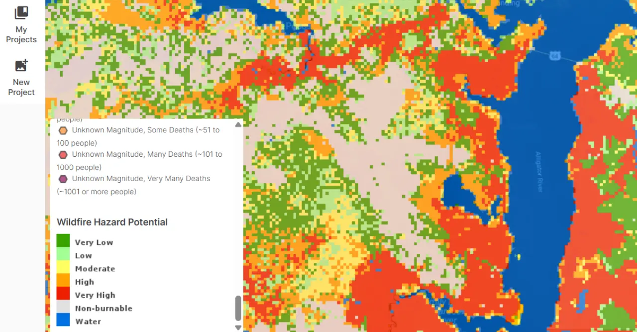
The Premium Wildfire Risk Assessment offers insights into the likelihood of a wildfire event impacting a site through burn probability layers. It provides current (2024) and projected (2054) burn probability at 30-meter resolution nationwide. Built upon the First Street Wildfire Model, the data also incorporates climate change impacts.
By using this information, developers can identify high-risk areas early for targeted vegetation management and fire suppression strategies. This also enables better long-term planning, allowing them to factor wildfire risk into site selection and operational plans, such as the planning of defensible spaces around installations and the selection of fire-resistant materials.
Premium Wind / High Hurricane Wind Risk
In areas prone to severe weather, understanding wind risk is essential to developing a solar project.
This specifically focuses on hurricane wind risk, providing crucial insights for the structural integrity of solar installations. Using the First Street Wind Model’s data, this layer shows up to 3-second wind speed (mph) for various return periods (e.g., 50-year, 100-year, 500-year events). The model is probabilistic and climate-adjusted, focusing on the East Coast and Southeast at a 30-meter resolution.
Such a level of detail allows for planning and mitigation of damage from extreme wind events, as it provides invaluable information during structural design and component selection, such as anchoring systems, racking structures, and module durability Thus, it ensures the project’s longevity.
Premium Hail Model (coming soon)
A forthcoming feature, the Premium Hail Model, will add another layer of protection to the project. The layer will offer insights into the potential for damage from hailstones (e.g., 35mm stones) and help guide the choice of solar modules and other components that are more resilient to hail damage. It will also support the implementation of protective measures and insurance strategies based on localized hail risk.
The indispensable edge in a changing climate
In a world where environmental threats increasingly impact energy development, PVcase Prospect offers solar developers a distinct advantage. By integrating advanced climate information, our platform directly addresses the biggest obstacles projects face.
The platform prevents wasted time and investment on unsuitable sites, optimizes land acquisition, and defers costly initial H&H studies. Moreover, it accelerates early site evaluation, delivering precise, climate-informed layouts faster. Ultimately, PVcase Prospect transforms unseen environmental dangers into useful information, safeguarding your solar installations.
Site selection guide
Download the e-book to:
Accelerate site identification.
Reduce risks & optimize viability.
Streamline your workflows.
Maximize project value.